AP Transit Logo


AP Transit

PATH Journal Square–33rd Street

PATH trains between Journal Square and 33rd St, Manhattan.

JSQ–33rd St train station list

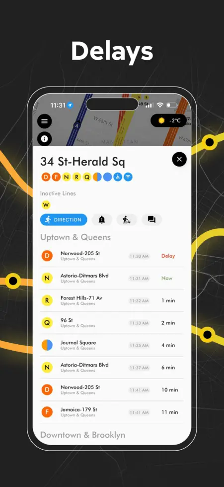
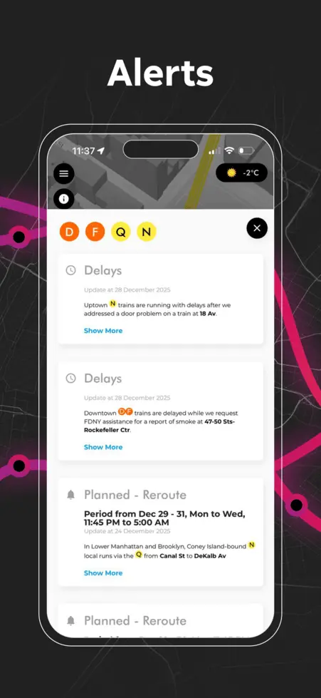
J3 PATH Journal Square–33rd Street Status & Alerts

    No Alerts

PATH JSQ–33rd St FAQ

Route, Stops & Service Pattern

What is the route of the PATH JSQ–33rd St?

Service operates between Journal Square and 33rd St, Manhattan. Officially labeled as the PATH Journal Square–33rd Street.

Is the PATH JSQ–33rd St line operating right now, and how many PATH JSQ–33rd St trains are running?

Yes. The PATH JSQ–33rd St line is operating, but our station snapshot flags Service issues on the line—many stops show gaps or irregular arrivals for this route. Our live feed maps about 4 active train(s) on this line right now.

Is PATH JSQ–33rd St service running normally right now?

Right now our algorithm rates this line as Service issues on the line based on recent wait times and live reliability. There are no active alerts for this route in our feed right now.

What are the operating hours for JSQ–33rd St?

Operates on a frequent schedule connecting NJ and NY. For live PATH hours, maps, and trip tools, use AP Transit on our homepage.

How much does a PATH JSQ–33rd St train ride cost (TAPP, OMNY, Apple Pay, card)?

The standard one-way PATH fare on the JSQ–33rd St line is $3.00 (official PANYNJ PATH base fare as of May 2026) when you pay with PATH TAPP, SmartLink, or—where installed—OMNY using a contactless credit or debit card, Apple Pay, or Google Pay. Not every gate supports every payment method yet. PATH zones, promotions, and cross-system rules differ from the NYC Subway—for discounts, reader availability, and fare tools, open AP Transit on our homepage.

How do I pay for PATH?

PATH accepts Pay-Per-Ride TAPP and SmartLink. OMNY is rolling out station-by-station—see what your stop supports on AP Transit.

Which PATH JSQ–33rd St stations have accessibility (ADA)?

These stations on this line are marked as fully ADA accessible in our static database (always verify elevators and gates on site):

Accessible stops
Grove Street, Newport, Christopher Street, Journal Square, 33rd Street

For elevator status and accessible routing in AP Transit, use AP Transit on the map.

How often does the J3 train come, and what is the maximum wait?

Right now, J3 trains are arriving approximately every 3 minutes on average. In our current measurement window, the longest gaps between J3 trains reach about 4 minutes (worst-case spacing—your station and direction may differ).

Which stations may have spacing issues for the next J3 train (ETA on the arriving train)?

No stops on this line currently show a next-J3 ETA score under 60 for the arriving train in our snapshot. This view updates automatically; if headways worsen, check Status & Alerts below or AP Transit.

Which PATH JSQ–33rd St stations currently have no service or a closed direction?

Below is one snapshot from the same feed as the No Service arrows on this page, but filtered to JSQ–33rd St only (other lines can still show times here). Stations are grouped by how JSQ–33rd St is missing in our feed—at most two panels.

One direction
For JSQ–33rd St, one direction is not running in our snapshot (the other side may still show a countdown). Stops: Grove Street, Christopher Street, Journal Square, 9th Street, 33rd Street. More detail on our map: AP Transit.

All Lines

Live NYC subway map showing real-time train positions and routes across New York City
3D NYC subway map with elevated view of Manhattan streets, stations, and live train lines
NYC subway station delay board showing upcoming trains, wait times, and service status
Real-time NYC subway map displaying live moving trains and active routes
iOS home screen widgets showing upcoming NYC subway arrivals and last stop information
NYC subway transfer map for stations with connecting lines and platforms
NYC subway station entrances map with line connections and exit locations
NYC subway service alerts screen showing delays, reroutes, and planned service changes
PATH train map connecting New York City and New Jersey with live route visualization
NYC subway route planner showing travel path
AP Transit

Download App

Real-time NYC subway, PATH, JFK AirTrain, route planning, station exits, transfer guidance, and service alerts in one map.